The SECCE
Southeast Christchurch Coastal Environment · Our case study
Our case study area
The Southeast Christchurch Coastal Environment (SECCE) is located around 6 km southeast of Christchurch. It extends along a 7 km arc from New Brighton Beach in the north to Godley Head in the southeast.
The map
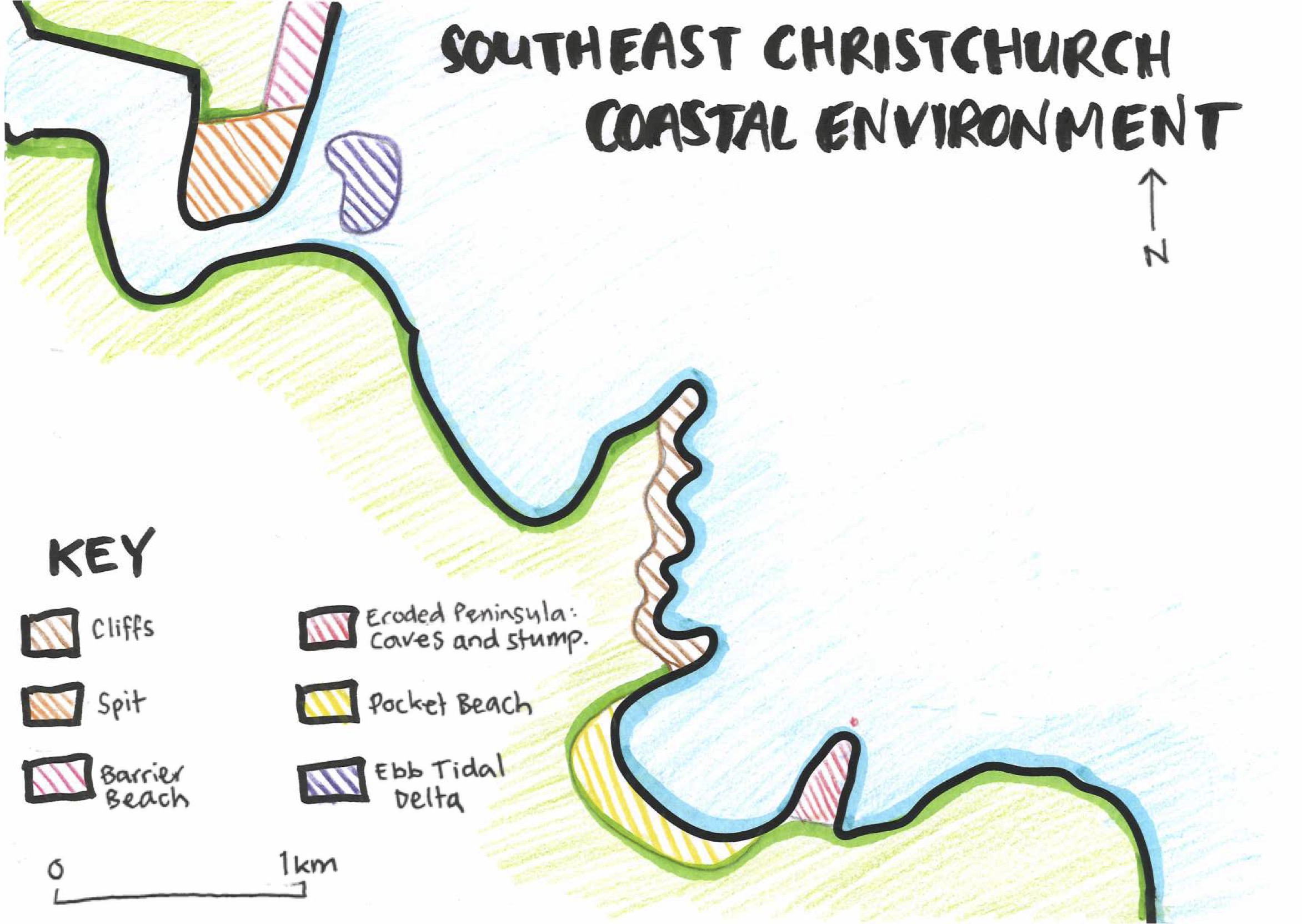
Practise drawing it. You need to practise drawing this outline and locating and labelling the key features. You should be able to identify the type of landform (e.g. barrier beach), and also add the place name (e.g. New Brighton Beach).
Make sure you use a definite border and that the pattern you use is the same on the landform as it is in the key. Using different solid colours is easiest, or consistent diagonal lines like on the map.
Time-lapse video of the map
The interacting natural processes
Tectonic processes
- Volcanism
- Tectonic uplift
Marine processes
- Wave refraction
- Wave diffraction
- Wave action
- Wave erosion
- Wave transportation
- Wave deposition
- Tidal action
Climatic processes
- Aeolian processes
- Aeolian erosion
- Aeolian transportation
- Aeolian deposition
- Weathering
Fluvial processes
- Fluvial deposition
How the processes operate in the SECCE
Tectonic processes
The coastline from Southshore Spit to Godley Head is based around the eroded remains of the Lyttelton Volcano, part of Banks Peninsula’s Miocene volcanic complex.
Around 10.5 million years ago, repeated effusive basaltic eruptions created a shield volcano of highly fractured and jointed rock.
Intrusion by thicker, high-viscosity magma formed trachyte dykes (vertical walls of erosion-resistant lava). Gentle tectonic uplift continues to expose the volcanic rock to coastal erosion. This is most evident at Scarborough Headland.
The Port Hills mark the caldera rim of the extinct Lyttelton Volcano; their erosion-resistant volcanic rocks form the prominent headlands of Scarborough and Godley Head.
Wave refraction
In Canterbury, Banks Peninsula serves as an obstacle to the predominant southerly and southeasterly waves that travel along the coast of the South Island. Refraction bends these waves around the peninsula, meaning that the dominant wave direction in the SECCE is easterly, with a typical wave height of 0.5 to 2.0 metres and a wave period of 7 to 11 seconds.
As the waves approach the SECCE, the headland and bay coastline influences how wave action (wave erosion, wave transportation, wave deposition) operates. This leads to features formed by wave erosion on the headlands, and features formed by wave deposition in the bays.
The landforms
Erosion features: Scarborough Headland (coastal cliffs) · Black Rock Point (eroded peninsula, caves and stump)
Deposition features: New Brighton Beach (barrier beach) · Southshore Spit · Taylors Mistake (pocket beach) · Ebb Tidal Delta
Using it in the exam
Set the scene. The teacher marking your answer will be from a different part of the country, and will be marking different types of landscapes, so introduce the SECCE and the processes and landforms you’ll talk about. For example:
“The Southeast Christchurch Coastal Environment (SECCE) is located around 6 km southeast of Christchurch. The SECCE coastline extends along a 7 km arc from New Brighton Beach in the north to Godley Head in the southeast. A combination of tectonic, marine, fluvial and tidal processes have interacted to create a range of coastal erosion features (coastal cliffs, eroded headlands, caves and a stump), as well as deposition features (beaches, spit, ebb tidal delta).”
Question A map: draw the whole SECCE with a key, add the place names (Scarborough Headland, Black Rock Point, Sumner Beach, Taylors Mistake, Godley Head and so on) and a short caption for each landform. Make sure there is a title, north point and scale.
Practise it: Map the SECCE and Identifying Processes.